PSB-5 launched

PSB-5 was released and recovered yesterday.

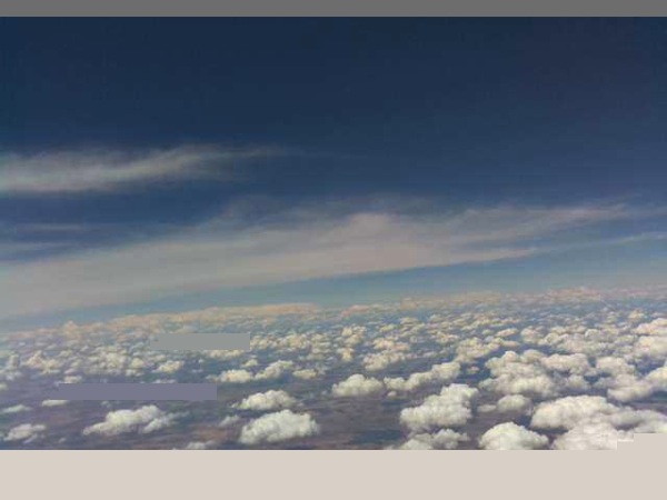
Photo

The flight lasted 5 hours, gaining maximum altitude of 18,914m.

We were able to test HF telemetry on multi bands and multi protocols with hams and non-hams around Australia. Telemetry was received from as far as WA 2,500km away.

THOR4 was very good with HF noise, and was easy to use with dl-fldigi. It would make a good choice for HF telemetry.

JT65 was solid, however some work will need to be done to integrate it with spacenear.us tracking site. With the limitation of 13 characters of free-text per message, it would be ideal for an extension of the JT65/9 family of protocols to be developed for telemetry. The time-synced start of transmission is also not optimal for mobile telemetry tracking.

WSPR was working well, we had 26 WSPR spots on all bands, the majority was on 30m. The main advantages of WSPR for us is the reliability, and number of existing receiving stations. Like JT65, extension to the protocol would be required to make it useful for HF tracking.

Most of the initial HF telemetry was received on 30m at the time of launch, and we could see 40m and 20m coverage coming in at the end of the flight. For future flights we probably will use only 30m and 20m for telemetry.

The star of the experiment however was the Raspberry Pi computer that was multi-tasking all HF protocol encoding and transmission, and house-keeping tasks, including GPS sync for time and frequency, RF generation, SSDV image encoding, communicating with GPS tracker, under extreme conditions that saw the ambient temperature rising to 66 degree Celsius (payload insulation was working too well!), and constant payload movement.

The complex payload could not have been developed and tested in such a short time for us without the versatile linux environment on the Pi. It does have limitations but we managed to address many of them for the flight. Still more work to do, but the Raspberry Pi has proven to be a very versatile and mature platform for ham radio and HAB experimenting.

A big thank-you to everyone for assistance with tracking, and testing before the launch.

Credits also goes to various people that contributed to the softwares and protocols associated with the experiment, such as Joe Taylor K1JT, Oliver Mattos and Oskar Weigl who implemented PiFM, MD1CLV, PE1NNZ for coding WSPR on the Pi, who gave us the idea of implementing other protocols on the Pi, and Philip Heron for SSDV codes.

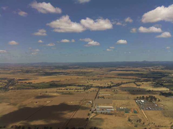
SSDV photos
2013 11 16 01 11 36 PSBPI 61F

2013 11 16 02 58 05 PSBPI 624

Payload landing site

2013 11 16 07 28 05 PSBPI 62B

PSB-5

PSB-5 will be launched from Bendigo on 16th November 2013.

We are sending away a Raspberry Pi with high-def Pi-Cam camera, interfacing to our standard tracker.

Photo

One main objective of the flight is to test HF tracking. DominoEX8 THOR4, JT65 and WSPR will be the three transmission protocols, beside the usual RTTY/SSDV on UHF.

DominoEX8 was chosen as one of the protocols to be tested on the flight, but initial tests showed that without Forward Error Correction (FEC), it was lagging far behind JT65, at least in our intended application of telemetry tracking on HF.

Thanks to a suggestion by Mark VK5QI, we replaced DominoEX8 with THOR4 at the last minutes, and that looks much better. THOR4 uses the same modulation scheme as DominoEX8 (incremental FSK) but with FEC.

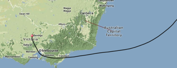
The predicted path should be something like this, but we will need to run the prediction closer to the date.

Untitled 9

The payload will send back SSDV images and telemetry on UHF until it is beyond radio line-of-sight. After that HF will be the only way of getting telemetry from the payload, assuming we can keep it afloat until then :)

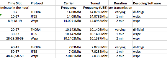
To assist with tuning, the HF transmissions will be assigned different time slots, which are just the number of minutes in the hour.

Untitled 2

Basically it is transmitting on 20m band in the first 20 minutes of the hour, 30m band in the second 20 minutes and 40m band in the last 20 minutes. Please note the JT65 frequencies are not standard JT65 QSO frequencies.

In each 20 minute interval there will be 8 minutes of THOR4, 8 minutes of JT65, and 4 minutes of WSPR.

On UHF it will be 434.650MHz, RTTY 300baud, 8 None 1, 450Hz shift.

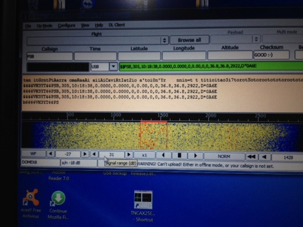
dl-fldigi can be used to decode RTTY/SSDV and THOR4. The data format for THOR4 is the same as normal RTTY telemetry, ie. sentences with call sign, sequence number, time, coordinates, altitude, speed, satellites, GPS status and battery voltage as can be seen in this fldigi decode for DominoEX8.

IMG 1299

Check here for instruction on RTTY/SSDV decoding: http://projectspaceballoon.net/ssd/

With JT65, we will need to use WSJTX software from Joe Taylor http://www.physics.princeton.edu/pulsar/K1JT/wsjtx.html

The existing JT65 protocol has a limitation of 13 characters per message, so our telemetry data will be sent as two JT65 packets:
Packet #1: VK3YT+Altitude(4 digits)+Satellite(2 digits)+Temperature(2 digits)
Packet #2: Lat+Long without decimal point+temperature sign (-/+)

Untitled 6

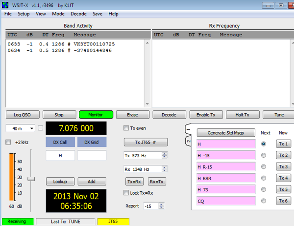
In the screen capture, the two lines of test telemetry are:
VK3YT00110725 & -37480144846

This translates to:
- Altitude = 0011 * 100 = 1100m
- Number of Satellites = 07
- Temperature = 25C
- Lat = -37.480
- Long= 144.845

If you receive JT65 telemetry from the payload, please send a screen capture or the two lines to info@projectspaceballoon.net and we will manually upload that to spacenear.us. If JT65 proves to be viable for long range telemetry we will look at integrating the decoding software with spacenear.us

WSPR can be decoded using WSPR software http://physics.princeton.edu/pulsar/K1JT/wspr.html

You can check the WSPR spots (received transmissions from a WSPR beacon) here http://wsprnet.org/olddb.

WSPR propagation map can be found here http://wsprnet.org/drupal/wsprnet/map

When looking for the signals, the HF frequency should be quite accurate as that is GPS compensated. You will need to check the transmission timeslot table, and look for the signals either audibly or visually.

This is spectrum sample for a THOR4 signal.

Untitled 3

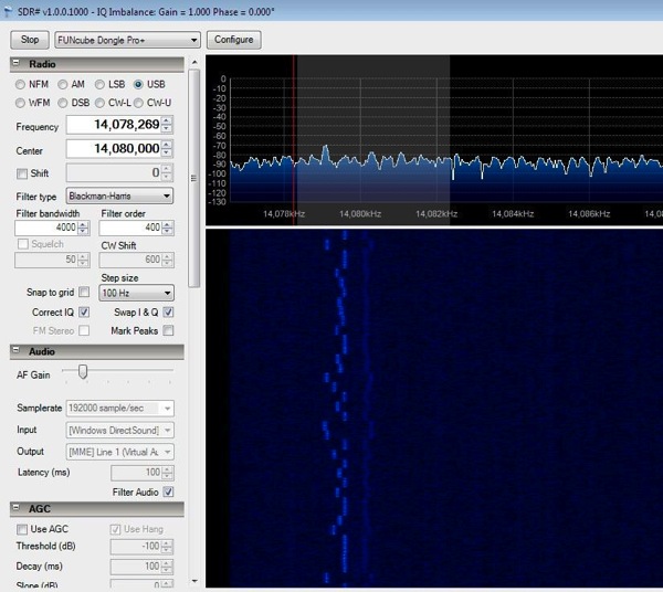
This is spectrum sample for a JT65 signal. Note the very narrow bandwidth of less than 400Hz. Each JT65 transmission starts on the second second of the minute and completes in 46 seconds. Therefore time on the computer has to be accurate within 1 second of UTC time. Please consider syncing the time with internet time servers

PastedGraphic 1

Actual RF spectrum from the Pi after a LPF

Photo

Tracking data will be uploaded on the day to http://spacenear.us/tracker

Initial testing looks promising, this is a WSPR transmission received from the payload. The distance is 16,000km.

Untitled

PSB-4 up and away!

PSB-4 lifted off in very strong wind condition yesterday

PICO launch

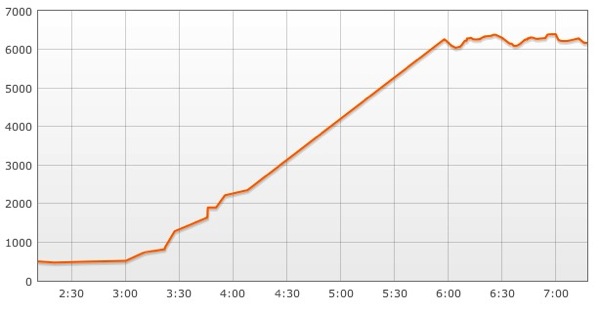
Solar panel worked well, the payload was powered for 5 hours until it shut down at low light, covering a distance of about 350km. Floating altitude was 6200m.

Telemetry transmission would resume when the solar panel gets enough sunlight the next day.

This was also our first field test of the new GPS module MAX-7C. It was working fine, and being very power efficient it was perfectly suitable for PICO flights.

A big thank you to everyone for assistance with tracking at a short notice. The 6200m altitude didn’t give us a good radius of radio horizon like previous flights at higher altitudes. Peter VK3XCO and VK3ZYC did a good job of getting most of the telemetry packets as the payload headed towards the Tasman.

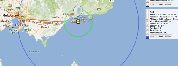
Flight path:

PastedGraphic 9

Altitude:

PastedGraphic 6

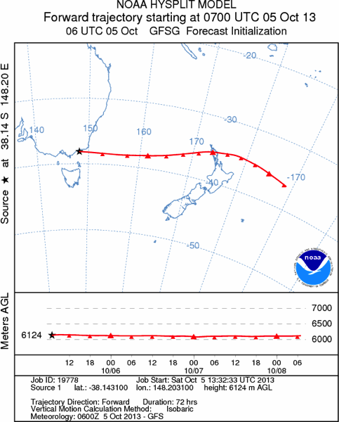
If the balloon remains afloat, predicted trajectory shows an Easterly path towards the northern part of New Zealand, and should be within reception range of Auckland around 9am Monday 7 October local time . It would be interesting to see if anyone can hear the payload again.

19778 trj001

For power saving we had the payload sending sequences of beeps at a few seconds apart, followed by telemetry packets at 434.650Mhz USB, 100baud RTTY with 440Hz shift, ASCII 8,None,1. The frequency was drifting to 434.653 the last time it was heard.

The audio beeps are very distinctive, and we’d love to hear reports of anyone who thinks they might have heard PSB-4! Please send reports to info@projectspaceballoon.net. The balloon will only transmit if the solar panel generates enough power, ie. 10am to 4pm local time.

Solar PICO

This is the first test of our solar pico

Photo

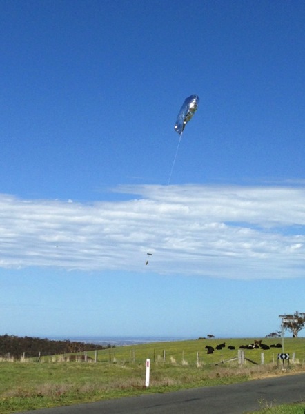
We plan to release the PICO in Ballarat today (5th Oct), to test out the Solar panel, and light weight payload on a foil balloon. At 15g including solar panel this is our lightest payload so far.

Photo

The max expected altitude is around 6000/7000m so we are not sure what the radio reception radius will be, will call out to the mailing lists for help if this starts looking promising!

We don’t expect to recover this payload if it stays up for a while.

The tracking telemetry is as previous flights:

434.650Mhz USB, 100baud RTTY, ASCII 8,None,1

Tracking on spacenear.us as PSB-4 http://spacenear.us/tracker/